 |
| AP Board Class 6 Social Science Chapter 3 Maps Textbook Solutions PDF: Download Andhra Pradesh Board STD 6th Social Science Chapter 3 Maps Book Answers |
Andhra Pradesh Board Class 6th Social Science Chapter 3 Maps Textbooks Solutions PDF
Andhra Pradesh State Board STD 6th Social Science Chapter 3 Maps Books Solutions with Answers are prepared and published by the Andhra Pradesh Board Publishers. It is an autonomous organization to advise and assist qualitative improvements in school education. If you are in search of AP Board Class 6th Social Science Chapter 3 Maps Books Answers Solutions, then you are in the right place. Here is a complete hub of Andhra Pradesh State Board Class 6th Social Science Chapter 3 Maps solutions that are available here for free PDF downloads to help students for their adequate preparation. You can find all the subjects of Andhra Pradesh Board STD 6th Social Science Chapter 3 Maps Textbooks. These Andhra Pradesh State Board Class 6th Social Science Chapter 3 Maps Textbooks Solutions English PDF will be helpful for effective education, and a maximum number of questions in exams are chosen from Andhra Pradesh Board.Andhra Pradesh State Board Class 6th Social Science Chapter 3 Maps Books Solutions
| Board | AP Board |
| Materials | Textbook Solutions/Guide |
| Format | DOC/PDF |
| Class | 6th |
| Subject | Social Science |
| Chapters | Social Science Chapter 3 Maps |
| Provider | Hsslive |
How to download Andhra Pradesh Board Class 6th Social Science Chapter 3 Maps Textbook Solutions Answers PDF Online?
- Visit our website - Hsslive
- Click on the Andhra Pradesh Board Class 6th Social Science Chapter 3 Maps Answers.
- Look for your Andhra Pradesh Board STD 6th Social Science Chapter 3 Maps Textbooks PDF.
- Now download or read the Andhra Pradesh Board Class 6th Social Science Chapter 3 Maps Textbook Solutions for PDF Free.
AP Board Class 6th Social Science Chapter 3 Maps Textbooks Solutions with Answer PDF Download
Find below the list of all AP Board Class 6th Social Science Chapter 3 Maps Textbook Solutions for PDF’s for you to download and prepare for the upcoming exams:Question 1.
What are the components of a map?
Answer:
The components of the map are
- Directions,
- Scale,
- Symbols and
- Colours.
Question 2.
Why is the actual distance on the ground reduced on a map?
Answer:
It is impossible to draw a map showing actual distances. So we use ‘scale’ to show the actual distance on the ground in a reduced manner on a map.
Question 3.
Explain the need for symbols in preparing maps.
Answer:
Maps are too small for us to draw pictures of the things shown on them. For example, we can’t draw the real school or a bus stand or a tree as they will take too much space on the map. Therefore, we always show things with the help of symbols on the map.
Question 4.
Find out the scale used in your district map to show the distance between your Mandal headquarter and district headquarter?
Answer:
Student Activity (One example is given for you).
Ex: Our mandal is Agiripalli. It is in the Krishna district. Our district headquarter is Machilipatnam.
On the map, the scale is given as 1 cm = 10 km.
The actual distance from Agiripalli to Machilipatnam is 83 km.
The distance between Agiripalli to Machilipatnam is 8.3 cms on the map.
Question 5.
How political maps are different from physical maps.
Answer:
Political maps show territorial features like country, cities, nations, and their boundaries. A physical map indicates the natural features of a place like mountains, water bodies, plains, etc.
Question 6.
What is the importance of thematic maps?
Answer:
A thematic map shows the spatial distribution of earth surface features. Thematic maps are used to display geographical concepts such as density, distribution, relative magnitudes, gradients, spatial relationships and movements. These maps focus on specific information like the map of rainfall, roads, tourist places etc..
Question 7.
What are the uses of maps in our daily life?
Answer:
Maps help us in many ways in our daily life. They help us to understand the concept of a subject.
- Maps help us to locate places like cities, districts, states and countries.
- Maps show the physical features such as mountains, plateaus, plains.
- Maps help us to know the major routes of transport such as roads, railways, etc.
- Maps help us to understand the distribution of crops, minerals, soils etc.
- Maps help the army at the time of war and for security reasons.
- Maps guide the tourists to their destination.
- Maps help us to understand history easily.
Question 8.
Locate all continents and oceans on the given World map.
Answer: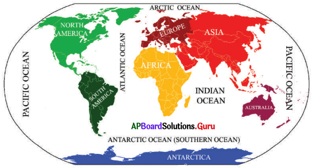
Choose the correct answer.
1) Maps showing the distribution of forests are …………….
A) Physical map
B) Thematic Map
C) Political map
D) none of the above
Answer:
B) Thematic Map
2) The blue colour is used for showing …………….
A) Waterbodies
B) Mountains
C) Land
D) Plains
Answer:
A) Waterbodies
3) A scale is a necessary component for …………….
A) Map
B) Sketch
C) Plan
D) None
Answer:
A) Map
4) A compass is used …………….
A) To show symbols
B) To find the main direction
C) To measure distance.
D) To find the height
Answer:
B) To find the main direction
5) The intermediate direction between the North and East is called …………….
A) North-east
B) South-east
C) North-west
D) South-west
Answer:
A) North-east
Project Work
Question 1.
Draw a sketch of your school.
Answer:
Student Activity.
Question 2.
Collect different maps and make a scrapbook.
Answer:
Student Activity.
Question 3.
Draw a sketch map showing the route from your home to school by using appropriate symbols.
Answer:
Student Activity.
6th Class Social Studies 3rd Lesson Maps InText Questions and Answers
Let’s Do
Question 1.
Why was Mrudula not able to reach her destination with the help of the above sketch? (Textbook Page No. 29 & 30)
Answer:
Mrudula was not able to reach her destination (Sathwika’s house) because there are no directions and scale in the given sketch.
Question 2.
Go through the below picture and fill in the following table. (Textbook Page No. 30 & 31)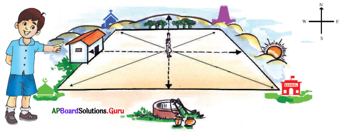
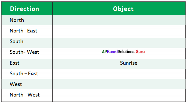
Answer:
| Direction | Object |
| North | Hill, Trees |
| North – East | Temple |
| South | Well |
| South – West | Masjid |
| East | Rising Sun |
| South – East | School |
| West | House |
| North – West | Church |
Question 3.
Observe the given picture and calculate the actual distance between the following places using the scale. (Textbook Page No. 32)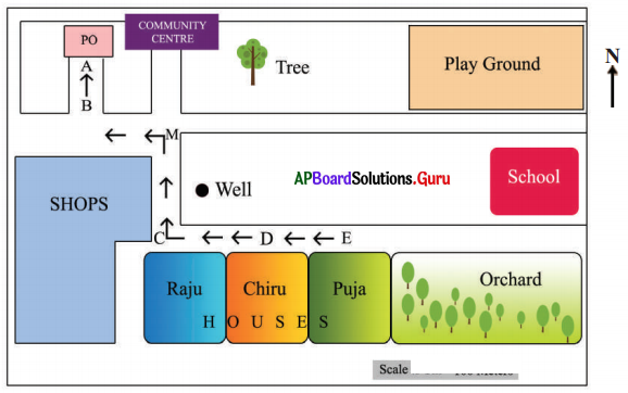
Answer:
i. The distance between PO (A) and Raju’s house (C).
Answer:
Approximately 60 metres.
ii. The distance between Raju’s house (C) and Puja’s house (E).
Answer:
Approximately 30 metres.
iii. The distance between Chiru’s house (D) and the school.
Answer:
Approximately 55 metres.
Question 4.
Make a table with the states, UTs and their capital. (Textbook Page No. 35)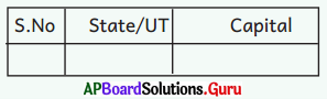
Answer:
| S.No. | State/UT | Capital |
| 1. | Andhra Pradesh | Amaravati |
| 2. | Arunachal Pradesh | Itanagar |
| 3. | Assam | Dispur |
| 4. | Bihar | Patna |
| 5. | Chattisgarh | Raipur |
| 6. | Goa | Panaji |
| 7. | Gujarat | Gandhinagar |
| 8. | Haryana | Chandigarh |
| 9. | Himachal Pradesh | Shimla |
| 10. | Jharkhand | Ranchi |
| 11. | Karnataka | Bengaluru |
| 12. | Kerala | Tiruvanantapuram |
| 13. | Madhya Pradesh | Bhopal |
| 14. | Maharashtra | Mumbai |
| 15. | Manipur | Imphal |
| 16. | Meghalaya | Shillong |
| 17. | Mizoram | Aizwal |
| 18. | Nagaland | Kohima |
| 19. | Orissa | Bhubaneswar |
| 20. | Punjab | Chandigarh |
| 21. | Rajasthan | Jaipur |
| 22. | Sikkim | Gangtok |
| 23. | Tamilnadu | Chennai |
| 24. | Telangana | Hyderabad |
| 25. | Tripura | Agartala |
| 26. | Uttar Pradesh | Lucknow |
| 27. | Uttarakhand | Dehradun |
| 28. | West Bengal | Kolkata |
| Union Territories and Capitals : | |||
| Andaman Nicobar Islands | Port Blair | ||
| Lakshadweep | Kavaratti | ||
| Ladakh | Leh | ||
| Chandigarh | Chandigarh | ||
| Dadar and Nagar Haveli Daman and Diu | Silvassa | ||
| Puducherry | Pondicherry | ||
| National Capital Region | New Delhi | ||
| Jammu & Kashmir | Srinagar (Summer) Jammu (Winter) |
Question 5.
Go through the below physical map and write some physical features of India. (Textbook Page No. 35)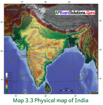
Answer:
India has all major physical features of the earth i.e., mountains, plains, deserts, plateaus and islands.
- The Himalayan mountains or the Northern Mountains.
- The Northern plains or the Indo – Gangetic Plains.
- The Peninsular Plateau.
- The Great Indian desert
- The Coastal Plains.
- The Islands.
Question 6.
Collect different thematic maps and display in your classroom. Discuss with your Mends. (Textbook Page No. 36)
Answer:
Student Activity.
Think and Respond
Question 1.
How do symbols give us information? (Textbook Page No. 32)
Answer:
With the help of symbols, maps can be drawn easily and are simple to read also. It is not possible to draw a map in the actual shape and size with different features such as buildings, rivers, bridges, trees and railway lines etc. So they are shown by using certain colours, letters, shades, pictures and lines.
Question 2.
What does the map indicate? (Textbook Page No. 36)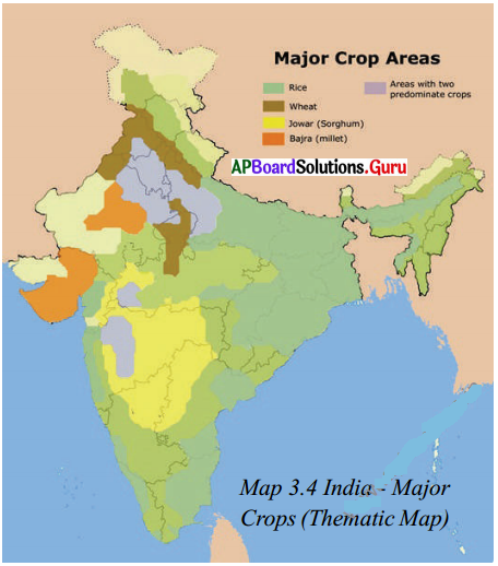
Answer:
This is a thematic map of India. Major crop-grown areas were shown on this map. From this map, we can know in which areas of India Rice, Wheat, Jowar, Bajra were grown. We can also know where two crops were grown.
Question 3.
Why it is called a thematic map? (Textbook Page No. 36)
Answer:
Thematic maps are called so because they focus on a specific theme or subject relating to a particular theme or aspect of geography like the map of rainfall, roads, tourist places.
AP Board Textbook Solutions PDF for Class 6th Social Science
- AP Board Class 6
- AP Board Class 6 Social Science
- AP Board Class 6 Social Science Chapter 1 Our Earth in the Solar System
- AP Board Class 6 Social Science Chapter 2 Globe Model of the Earth
- AP Board Class 6 Social Science Chapter 3 Maps
- AP Board Class 6 Social Science Chapter 4 Land Forms Andhra Pradesh
- AP Board Class 6 Social Science Chapter 5 Early Life to Settled Life
- AP Board Class 6 Social Science Chapter 6 Early Civilisations
- AP Board Class 6 Social Science Chapter 7 Emergence of Kingdoms and Republics
- AP Board Class 6 Social Science Chapter 8 Kingdoms and Empires
- AP Board Class 6 Social Science Chapter 9 Government
- AP Board Class 6 Social Science Chapter 10 Local Self Government
- AP Board Class 6 Social Science Chapter 11 Indian Culture Languages and Religions
- AP Board Class 6 Social Science Chapter 12 Towards Equality
- AP Board Class 6 Social Science Chapter 1 సౌర కుటుంబంలో మన భూమి
- AP Board Class 6 Social Science Chapter 2 గ్లోబు – భూమికి నమూనా
- AP Board Class 6 Social Science Chapter 3 పటములు
- AP Board Class 6 Social Science Chapter 4 ఆంధ్రప్రదేశ్ – భూస్వరూపాలు
- AP Board Class 6 Social Science Chapter 5 సంచార జీవనం నుండి స్థిర జీవనం
- AP Board Class 6 Social Science Chapter 6 తొలి నాగరికతలు
- AP Board Class 6 Social Science Chapter 7 సామ్రాజ్యాలు, గణతంత్రాల ఆవిర్భావం
- AP Board Class 6 Social Science Chapter 8 రాజ్యాలు మరియు సామ్రాజ్యాలు
- AP Board Class 6 Social Science Chapter 9 ప్రభుత్వం
- AP Board Class 6 Social Science Chapter 10 స్థానిక స్వపరిపాలన
- AP Board Class 6 Social Science Chapter 11 భారతీయ సంస్కృతి, భాషలు మరియు మతాలు
- AP Board Class 6 Social Science Chapter 12 సమానత్వం వైపు


0 Comments:
Post a Comment