 |
| AP Board Class 7 Social Studies 3rd Lesson Learning Through Maps Textbook Solutions PDF: Download Andhra Pradesh Board STD 7th Social Studies 3rd Lesson Learning Through Maps Book Answers |
Andhra Pradesh Board Class 7th Social Studies 3rd Lesson Learning Through Maps Textbooks Solutions PDF
Andhra Pradesh State Board STD 7th Social Studies 3rd Lesson Learning Through Maps Books Solutions with Answers are prepared and published by the Andhra Pradesh Board Publishers. It is an autonomous organization to advise and assist qualitative improvements in school education. If you are in search of AP Board Class 7th Social Studies 3rd Lesson Learning Through Maps Books Answers Solutions, then you are in the right place. Here is a complete hub of Andhra Pradesh State Board Class 7th Social Studies 3rd Lesson Learning Through Maps solutions that are available here for free PDF downloads to help students for their adequate preparation. You can find all the subjects of Andhra Pradesh Board STD 7th Social Studies 3rd Lesson Learning Through Maps Textbooks. These Andhra Pradesh State Board Class 7th Social Studies 3rd Lesson Learning Through Maps Textbooks Solutions English PDF will be helpful for effective education, and a maximum number of questions in exams are chosen from Andhra Pradesh Board.Andhra Pradesh State Board Class 7th Social Studies 3rd Lesson Learning Through Maps Books Solutions
| Board | AP Board |
| Materials | Textbook Solutions/Guide |
| Format | DOC/PDF |
| Class | 7th |
| Subject | Maths |
| Chapters | Social Studies 3rd Lesson Learning Through Maps |
| Provider | Hsslive |
How to download Andhra Pradesh Board Class 7th Social Studies 3rd Lesson Learning Through Maps Textbook Solutions Answers PDF Online?
- Visit our website - Hsslive
- Click on the Andhra Pradesh Board Class 7th Social Studies 3rd Lesson Learning Through Maps Answers.
- Look for your Andhra Pradesh Board STD 7th Social Studies 3rd Lesson Learning Through Maps Textbooks PDF.
- Now download or read the Andhra Pradesh Board Class 7th Social Studies 3rd Lesson Learning Through Maps Textbook Solutions for PDF Free.
AP Board Class 7th Social Studies 3rd Lesson Learning Through Maps Textbooks Solutions with Answer PDF Download
Find below the list of all AP Board Class 7th Social Studies 3rd Lesson Learning Through Maps Textbook Solutions for PDF’s for you to download and prepare for the upcoming exams:7th Class Social 3rd Lesson Learning Through Maps Textbook Questions and Answers
review of your previous knowledge: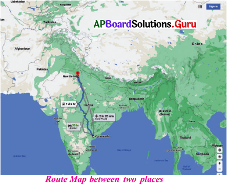
Observe the given map and respond.
Question 1.
What do you notice in the map?
Answer:
I noticed on the above map Route is drawn between Vijayawada to New Delhi.
And I noticed Different means of transport from Vijayawada to Delhi and the timings also mentioned. .
Through air way, time taken from Delhi to Vijayawada is 2 hrs. 20 min.
Through road way, time taken by car-30 hrs. and through railway, 1 day 2 hrs. time taken.
Question 2.
What does the blue mark (dotted line) in the map indicate?
Answer:
The dotted line in the map indicates the train route.
Question 3.
Name the neighbouring countries of India.
Answer:
Neighbouring countries of India are
- East – Mynmar, Bangladesh
- North – China, Nepal, Bhutan
- North – West – Pakistan, Afghanistan
- South -Srilanka
- South – West – Maldives
Question 4.
Can you name any two states in the given route?
Answer:
Two states
- Uttar Pradesh,
- Andhra Pradesh.
Question 5.
What are the different means of transportation shown in the map?
Answer:
Roadway, Railway & Airways are shown on the map.
Improve Your Learning
I. Answer the following questions.
Question 1.
How do you identify the direction in the map?
Answer: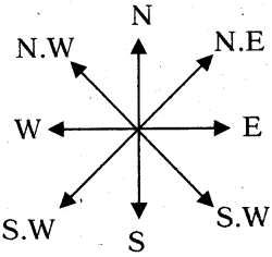
N – North, E – East, S – South, W – West, N.E – North East, S.E – South East, N.W – North West, S.W – South West.
Generally, maps are prepared showing the North direction on the top of the map. The direction can be noticed with the help of an arrow on the right top gcorner.
Question 2.
Scale in map helps to study a place. Discuss.
Answer:
Scale : It resembles the ratio of corresponding distance in map to actual distance.
Map scale helps us to study a place with the help of verbal scale – 1 cm = 10 kms, Graphical Scale and Represention function Ex : 1′ = 10,000′
Question 3.
What are the items you need to study a physical map?
Answer:
We need scale, directions, symbols, and colours are need to study a physical map.
Question 4.
Describe the location of India.
Answer:
Location of India :
- India is located in the northern hemisphere.
- The main land of India extends between latitudes 8°4’to 37° 6′ N and logitudes between 68° 7’to 97° 25° E.
- The Tropic of Cancer (23° 30’N) passes almost through the middle of the country.
- Apart from the mainland, the Andaman and Nicobar Islands and the Lakshadweep are also parts of India.
Question 5.
Prepare the list of countries in Asian Continent with the help of Atlas.
Answer:
50 countries are there in Asia.
| 1) India | 2) China | 3) Indonesia |
| 4) Japan | 5) Srilanka | 6) Pakistan |
| 7) Bangladesh | 8) Iran | 9) Phillippines |
| 10) Vietnam | 11) Turkey | 12) Thailand , |
| 13) Taiwan | 14) Mynmar | 15) South Korea |
| 16) Iraq | 17) Afghanistan | 18) Saudi Arabia |
| 19) Uzbekistan | 20) Malaysia | 21) Yemen |
| 22) Nepal | 23) Bhutan | 24) Brunei |
| 25) Maldives | 26) Cyprus | 27) Timorleste |
| 28) Bahrian | 29) Qatar | 30) Armenia |
| 31) Mangolia | 32) Georgia | 33) Kuwait |
| 34) State of Palestine | 35) Oman | 36) Singapore |
| 37) Turkmenistan | 38) Kyrgyzstan | 39) Lebanon |
| 40) Laos | 41) Israel | 42) Tajikistan |
| 43) UAE | 44) Azerbaijan | 45) Jordan |
| 46) Combodia | 47) Syria | 48) Kazakistan |
| 49) North Korea | 50) Russia. |
Question 6.
What are the boundaries of India?
Answer:
Boundaries of India are :
- North – Himalayan Ocean
- South – Indian Ocean
- East – Bay of Bengal
- West – Arabian Sea
Question 7.
Prepare the rough grid of India.
Answer: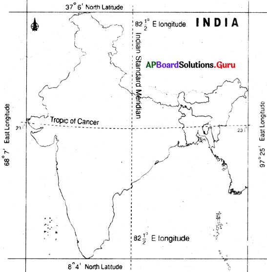
Question 8.
Locate the following in outline map of India.
a) Chennai
b) Delhi
c) Vijayawada
d) Visakhapatnam
Answer: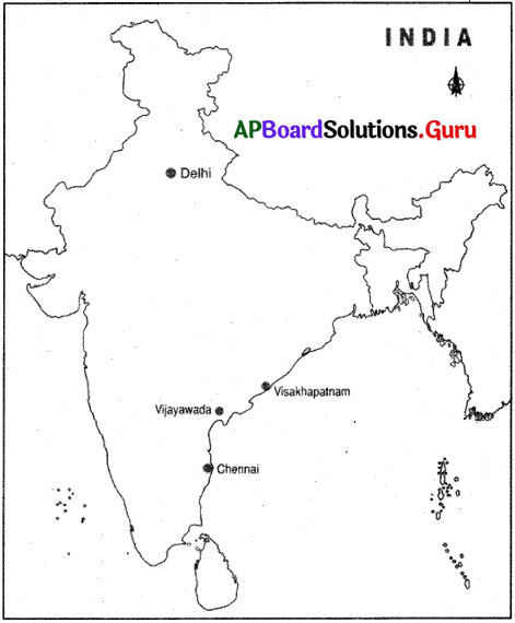
II. Choose the correct answer.
1. Find the correct sentence.
a) River Ganga originates in the Himalayas.
b) River Cauvery flows in West Bengal.
c) River Krishna drains into Arabian sea.
d) River Penna flows in Maharashtra.
Answer:
a) River Ganga originates in the Himalayas.
2. India lies in Eastern hemisphere between the longitudes of:
a) 14°27′ to 19°07′
b) 77° to 84°40′
c) 68°07′ to 97°25′
d) 8°4′ to 37°06′
Answer:
c) 68°07′ to 97°25′
3. Identify the odd one regarding the location of rivers.
a) Krishna
b) Penna
c) Brahmaputra
d) Cauvery
Answer:
c) Brahmaputra
4. a) Kerala is on west coast.
b) Arunachal Pradesh has border with Pakistan.
Note : Answer with the help of above information
a) ‘a’ is true; ‘b’ is false.
b) ‘a’ is false; ‘b’ is true
c) Both’a’and’b’are false.
d) Both of them are true.
Answer:
a) ‘a’ is true; ‘b’ is false.
5. Identify mismatched pair.
a) Chennai-Tamil Nadu
b) Bhopal – Gujarat
c) Jaipur – Rajasthan
d) Thiruvananthapuram – Kerala
Answer:
b) Bhopal – Gujarat
7th Class Social 3rd Lesson Learning Through Maps InText Questions and Answers
7th Class Social Textbook Page No. 35
Question 1.
Identify the elements of the map and write their names in map.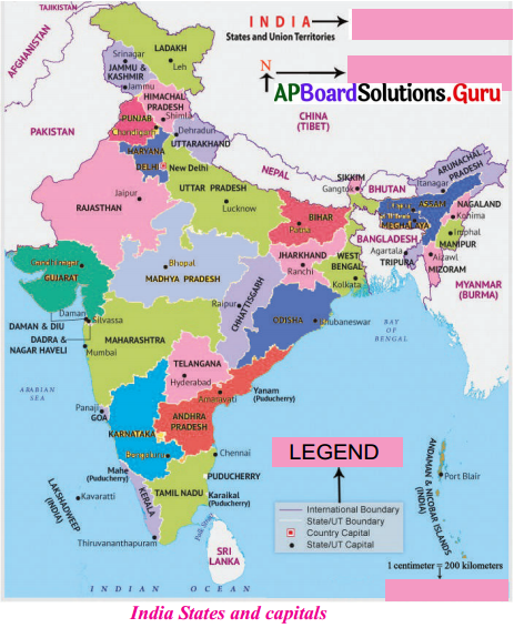
Answer: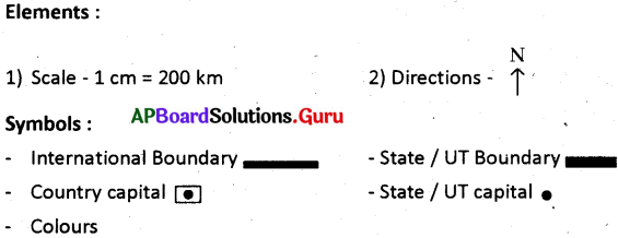
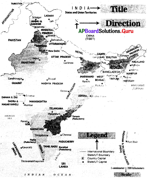
7th Class Social Textbook Page No. 36
Question 2.
Name the cardinal and intermediate directions in the adjacent image.
Answer:
1) Cardinal directions : 1) North, East, West, South
2) Intermediate directions : 1 – North East, North West, South East, South West.
Question 3.
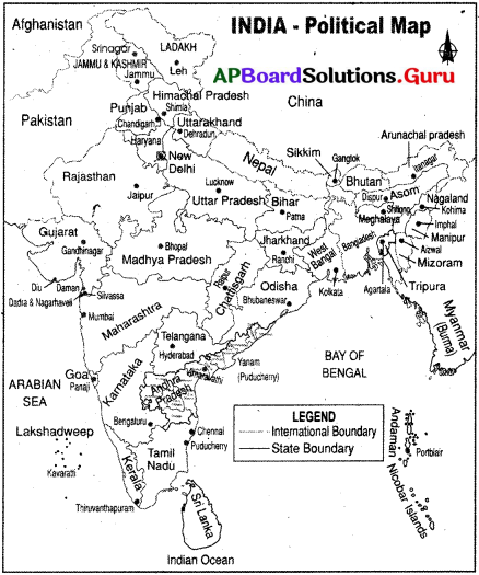
If you want to travel from Bengaluru to Itanagar, from which direction you have to travel?
Answer:
We should start from South-West direction Bengaluru and travel to North-East direction to reach itanagar.
Question 4.
Fill up the given table based on the scale given in the map – 3.2 (India States and Capitals).
| Places : From – To | Distance in the above map | Actual Distance |
| Chennai to Hyderabad | 3 cm | |
| Mumbai to Bhuvaneswar | 5 cm | |
| Panaji to Thiruvananthapuram | 2.5 cm | |
| Gandhinagar to Jaipur | 3 cm | |
| Kolkata to Ranchi | 3000 km | |
| New Delhi to Kohima | 2200 km |
Answer:
| Places : From – To | Distance in the above map | Actual Distance |
| Chennai to Hyderabad | 3 cm | 600 kms |
| Mumbai to Bhuvaneswar | 5 cm | 1000 kms |
| Panaji to Thiruvananthapuram | 2.5 cm | 500 kms |
| Gandhinagar to Jaipur | 2 cm | 400 kms |
| Kolkata to Ranchi | 15 cm | 3000 kms |
| New Delhi to Kohima | 11 cm | 2200 kms |
7th Class Social Textbook Page No. 38
Question 5.
Prepare a Map of Andhra Pradesh by using the elements discussed in the Index of the map.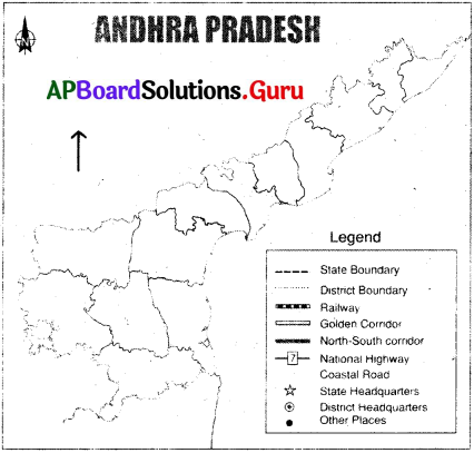
Answer: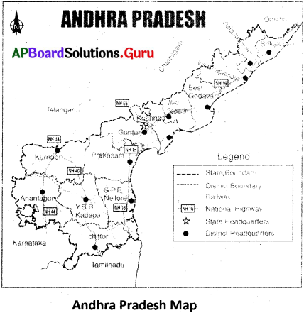
7th Class Social Textbook Page No. 40
Question 6.
Fill up the following table with the help of the India Political map that shares land frontier.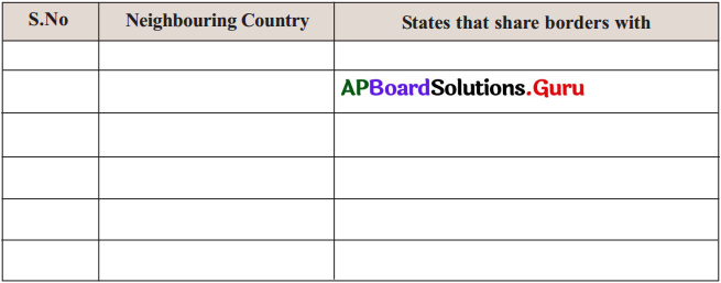
Answer:
| S.No. | Neighbouring Country | States that share borders with |
| 1. | Pakistan | Gujarat, Rajasthan, Punjab, Srinagar, Ladakh |
| 2. | Nepal | Uttarakhand, Uttar Pradesh, Bihar, West Bengal, Sikkim |
| 3. | Bhutan | Sikkim, West Bengal, Assom, Arunachal Pradesh |
| 4. | Bangladesh | West Bengal, Assom, Meghalaya, Tripura |
| 5. | Myanmar | Mizoram, Manipur, Nagaland, Arunachal Pradesh |
| 6. | China | Ladakh, Uttarakhand, Sikkim, Himachal Pradesh, Arunachal Pradesh |
Question 7.
Prepare the list of States and Union Territories; write their capitals.
Answer:
| State | Capital |
| 1. Andhra Pradesh | Amaravati |
| 2. Arunachal Pradesh | Itanagar |
| 3. Assom | Dispur |
| 4. Himachal Pradesh | Shimla |
| 5. Haryana | Chandigarh |
| 6. Punjab | Chandigarh |
| 7. Uttarakhand | Dehradun |
| 8. Uttar Pradesh | Lucknow |
| 9. Bihar | Patna |
| 10. Sikkim | Gangtok |
| 11. Nagaland | Kohima |
| 12. Manipur | Imphal |
| 13. Mizoram | Aizwal |
| 14. Meghalaya | Shillong |
| 15. Tripura | Agartala |
| 16. West Bengal | Kolkata |
| 17. Jarkhand | Ranchi |
| 18. Chhattisgarh | Rayapur |
| 19. Madhya Pradesh | Bhopal |
| 20. Gujarath | Gandhi Nagar |
| 21. Rajasthan | Jaipur |
| 22. Maharashta | Mumbai |
| 23. Goa | Panaji |
| 24. Karnataka | Bengaluru |
| 25. Kerala | Tiruvanantapuram |
| 26. Tamil Nadu | Chennai |
| 27. Orissa | Bhuvaneswar |
| 28. Telangana | Hyderabad |
Complete list of 8 Union Territories :
| Union Territories | Capital |
| 1. Andaman and Nicobar Island | Portblair |
| 2. Chandigarh | Chandigarh |
| 3. Dadra and Nagar Haveli, Daman and Diu | Daman |
| 4. Delhi | Delhi |
| 5. Ladakh | Leh |
| 6. Lakshadweep | Kavaratti |
| 7. Jammu and Kashmir | Srinagar and Jammu |
| 8. Puducherry | Pondicherry |
Question 8.
Take an outline map of India, draw the boundaries of states and loc te their capitals.
Answer:
7th Class Social Textbook Page No. 42
Question 9.
Prepare the list of Continents and a few important countries in each continent based on map – 3.5.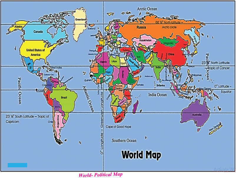
Answer:
| Continent | Important Countries |
| 1. North America | Alaska, Canada, U.S.A, Mexico etc. |
| 2. South America | Columbia, Equator, Peru, Venezula, Brazil, Chile, Argentina etc. |
| 3. Africa | Egypt, Libya, Algeria, South Africa, Kenya, Zimbabwe, Congo, Angola, Ghana etc |
| 4. Europe | England, France, Portugal, Poland, Germany, Italy, Switzerland, Russia, etc. |
| 5. Asia | India, China, Vietnam, Japan, Pakistan, Bangladesh, Korea, Malaysia etc. |
| 6. Australia | Indonesia |
| 7. Antarctica | No Countries. |
Question 10.
Name the continents through which the Equator runs.
Answer:
1 – South America
2 – Africa
3 – Asia
7th Class Social Textbook Page No. 43
Question 11.
Prepare a raised relief map with the guidance of your teacher.
Answer:
Question 12.
Fill up the following mind map with the help of the India- physical map (map-3.6) See Text Page: 42.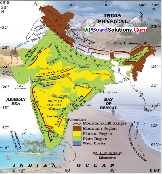
Answer: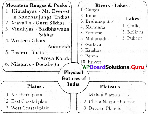
7th Class Social Textbook Page No. 45
Question 13.
Based on map 3.7 prepare a table with the distribution of soils. (Consider the type of soil and respective districts).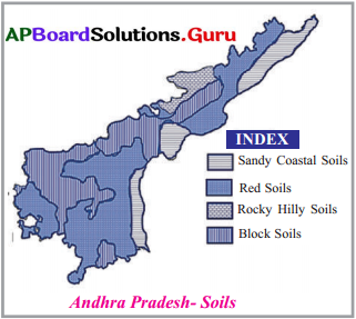
Answer:
| Soil Name | Districts / Distributed Area |
| 1. Sandy coastal soil | Srikakulam, Visakhapatnam East Godavari and Nellore district |
| 2. Red soil | Vijayanagaram, Visakhapatnam, Guntur, Prakasam, Nellore, Chittoor, Kurnool |
| 3. Rocky Hilly Soils | East Godavari, West Godavari |
| 4. Black soils | East Godavari, West Godavari, Krishna, Guntur, Kurnool, Anantapur |
Question 14.
Take an Andhra Pradesh map and prepare a Thematic map (Andhra Pradesh-Population Density Map) with the help of the given data.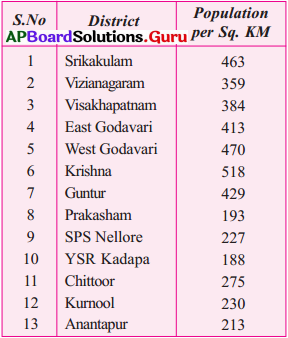
Answer:
Note – Write the figures in the concerned districts of Andhra Pradesh.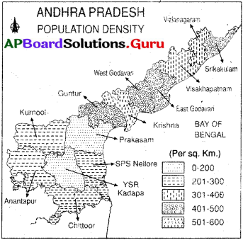
Question 15.
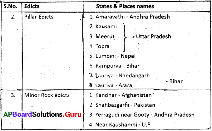
Prepare a table with edicts of Ashoka and their location in the present states based on map 3.9. See Text Page – 45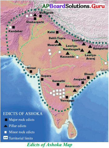
Answer: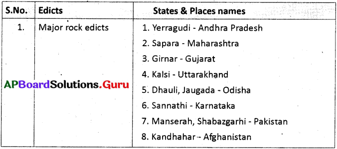
Think & Respond
7th Class Social Textbook Page No. 36
Question 1.
What is the use of scale in a map?
Answer:
Use of Scale :
Scale : The relationship between the real world size of a geographic features and its representative feature on a map, is known as scale.
- The map scale is used to measure the distance of actual.ground represented by the map.
- Scale help in calculating the area on the map.
- The scale Is used in map enlargement and reduction.
7th Class Social Textbook Page-Mo. 37
Question 2.
Why do we use symbols in a map?
Answer:
It is not possible to draw a map in the actual shape and size with different features such as buildings, roads, rivers, bridges, trees, railway lines, etc.
So they are shown by using certain letters, shades, colours, pictures and linds. These symbols give a lot of information and help in reading maps. These symbols are called conventional symbols.
7th Class Social Textbook Page No. 39
Question 3.
Name the types of maps.
Answer:
Maps are classified into 4 types.
- Political maps
- Physical maps
- Thematic maps and
- Historical maps
Question 4.
What do they (maps) denote?
Answer:
The maps explains the administrative units, physical features, population density, soils, minerals, inscriptions and architecture of India.
7th Class Social Textbook Page No. 40
Question 5.
Observe the given political map (Map-3.4)
Answer: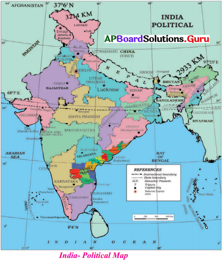
Question 6.
Name the state closest to equator.
Answer:
Tamil Nadu & Kerala both are closest to equator.
Question 7.
What is Tropic of Cancer?
Answer:
- Tropic of Cancer is at 23°30′ North latitude.
- It divides the India into two equal halves:
Question 8.
Name the states through which the Tropic of Cancer runs.
Answer:
Tropic of Cancer passes through Gujarat, Rajasthan, Madhya Pradesh, Chattisgarh, Jarkhand, West Bengal, Tripura, and Mizoram states.
7th Class Social Textbook Page No. 43
Question 9.
The rivers originated in Western Ghats flow towards east and join Bay of Bengal. Discuss with your teacher.
Answer:
- The rivers which are originated in Western Ghats originates at eastern side of the Western ghats in South India.
- As rivers cannot claim up, they flow towards slanting side.
- They flow through the Deccan Plateau which slopes towards east.
- Hence, the rivers flow towards east and join the Bay of Bengal.
Question 10.
Classify the rivers based on the seas they join. Name these rivers.
Answer:
Rivers are classified into two groups based on the seas they join.
- West flowing rivers.
- East flowing rivers.
| River Name | Sea | |
| 1. Ganga | Bay of Bengal | East flowing rivers |
| 2. Brahmaputra | Bay of Bengal | |
| 3. Mahanadi | Bay of Bengal | |
| 4. Krishna | Bay of Bengal | |
| 5. Godavari | Bay of Bengal | |
| 6. Penna | Bay of Bengal | |
| 7. Kaveri | Bay of Bengal | |
| 1. Indus | Arabian sea | West flowing rivers |
| 2. Narmada | Arabian sea | |
| 3. Tapiti | Arabina sea |
Question 11.
Mention land forms of Andhra Pradesh.
Answer:
The Andhra Pradesh state has three main physiographic regions.
1. Mountains 2. Plains 3. Plateau
- The coastal plain tothe east extending from the Bay of Bengal to the mountain ranges.
- The mountain ranges themselves, the Eastern Ghats, which form the western flank of the coastal plain.
- In the South west, the plateau to the west of the ghats.
Explore
7th Class Social Textbook Page No. 37
Question 1.
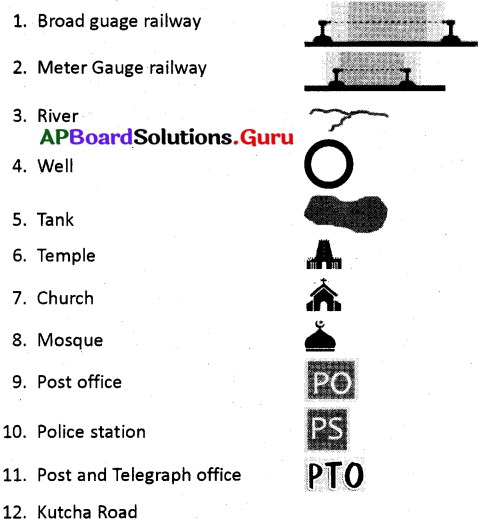
Explore more conventional symbols used by the Survey of India in the preparation of a map with the help of Atlas or through internet.
Answer:
Conventional Symbols :
- It is not possible to draw a map in the actual shape and size.
- Different features on the map shows with different symbols. Those are
| 1) Buildings | 2) Roads | 3) Bridges |
| 4) Trees | 5) Railway lines | 6) Broad gauge railway |
| 7) Meter guage railway | 8) River | 9) Well |
| 10) Tank | 11) Temple | 12) Church |
| 13) Mosque | 14) Post office | 15) Police station |
| 16) Kutcha road | 17) Mountain peak | 18) Grave |
7th Class Social Textbook Page No. 40
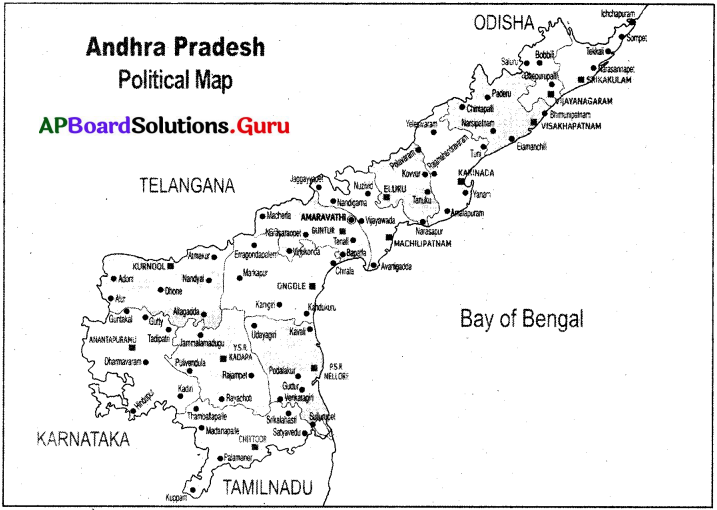
Question 2.
Explore the location of Andhra Pradesh with the help of Atlas.
Answer:
Andhra Pradesh lies between 12°41′ and 19°.07′ N latitudes. 77° and 84°.40′ E longitude.
7th Class Social Textbook Page No. 43
Question 3.
With the help of the Atlas explore about extension of various mountain ranges and the highest peaks in those respective ranges.
Answer:
| Mountain Range | Peaks |
| 1. Himalayas | Mt. Everest (Nepal), Kanchanajunga (India) |
| 2. Karakoram | Mt – K2 |
| 3. Aravallis | Gurushikhar |
| 4. Western Ghats | Anaimudi |
| 5. Eastern Ghats | Aroyakonda |
| 6. Nilgiris | Dodabetta |
| 7. Satpura Range | Dhupgarh |
| 8. Vindhya Range | Sadbhavna Shikhar |
| 9. Purvanchal Range | Mt Dapha |
Question 4.
Explore physical features of India with the help of the Atlas or go through the internet.
Answer:
The major physiographic divisions of India are :
- The Greater Himalayas
- The Northern plains
- The Great Indian desert
- The Peninsular plateau
- The Eastern and Western coastal plains and
- The Island group ‘
7th Class Social Textbook Page No. 46
Question 5.
Use the books in the library and the Atlas to explore various maps of dynasties related to ancient and medieval India.
Answer: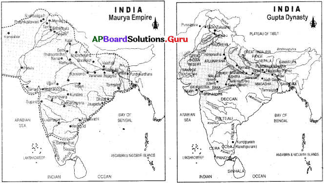
Project Work
Prepare a self-made Atlas by using tracing technic for different continents and political map of India, Andhria Pradesh and your district.
Answer:
1. Children need to prepare their own Atlas (Student Activity).
1.
2.
3.
AP Board Textbook Solutions PDF for Class 7th Social Studies
- AP Board Class 7
- AP Board Class 7 Social Studies
- AP Board Class 7 Social Studies 1st Lesson The Universe and The Earth
- AP Board Class 7 Social Studies 2nd Lesson Forests
- AP Board Class 7 Social Studies 3rd Lesson Learning Through Maps
- AP Board Class 7 Social Studies 4th Lesson Delhi Sultanate
- AP Board Class 7 Social Studies 5th Lesson Kakatiya Kingdom
- AP Board Class 7 Social Studies 6th Lesson Vijayanagara Empire
- AP Board Class 7 Social Studies 7th Lesson Mughal Empire
- AP Board Class 7 Social Studies 8th Lesson Bhakthi Sufi
- AP Board Class 7 Social Studies 9th Lesson Indian Constitution
- AP Board Class 7 Social Studies 10th Lesson State Government
- AP Board Class 7 Social Studies 11th Lesson Road Safety Education
- AP Board Class 7 Social Studies 12th Lesson Markets Around Us
- AP Board Class 7 Social Studies 13th Lesson Women Change the World
- AP Board Class 7 Social Studies Chapter 1 విశ్వం మరియు భూమి
- AP Board Class 7 Social Studies Chapter 2 అడవులు
- AP Board Class 7 Social Studies Chapter 3 పటాల ద్వారా అధ్యయనం
- AP Board Class 7 Social Studies Chapter 4 ఢిల్లీ సుల్తానులు
- AP Board Class 7 Social Studies Chapter 5 కాకతీయ రాజ్యం
- AP Board Class 7 Social Studies Chapter 6 విజయనగర సామ్రాజ్యం
- AP Board Class 7 Social Studies Chapter 7 మొఘల్ సామ్రాజ్యం
- AP Board Class 7 Social Studies Chapter 8 భక్తి – సూఫీ
- AP Board Class 7 Social Studies Chapter 9 భారత రాజ్యాంగం – పరిచయం
- AP Board Class 7 Social Studies Chapter 10 రాష్ట్ర ప్రభుత్వం
- AP Board Class 7 Social Studies Chapter 11 రహదారి భద్రత
- AP Board Class 7 Social Studies Chapter 12 మన పరిసరాలలో ఉన్న మార్కెట్లు
- AP Board Class 7 Social Studies Chapter 13 ప్రపంచ పరివర్తనలో మహిళలు
- AP Board Class 7 Social Studies Chapter 1 Reading Maps of Different Kinds
- AP Board Class 7 Social Studies Chapter 2 Rain and Rivers
- AP Board Class 7 Social Studies Chapter 3 Tanks and Ground Water
- AP Board Class 7 Social Studies Chapter 4 Oceans and Fishing
- AP Board Class 7 Social Studies Chapter 5 Europe
- AP Board Class 7 Social Studies Chapter 6 Africa
- AP Board Class 7 Social Studies Chapter 7 Handicrafts and Handlooms
- AP Board Class 7 Social Studies Chapter 8 Industrial Revolution
- AP Board Class 7 Social Studies Chapter 9 Production in a Factory A Paper Mill
- AP Board Class 7 Social Studies Chapter 10 Importance of Transport System
- AP Board Class 7 Social Studies Chapter 11 New Kings and Kingdoms
- AP Board Class 7 Social Studies Chapter 12 The Kakatiyas
- AP Board Class 7 Social Studies Chapter 13 The Kings of Vijayanagara
- AP Board Class 7 Social Studies Chapter 14 Mughal Empire
- AP Board Class 7 Social Studies Chapter 15 Establishment of the British Empire in India
- AP Board Class 7 Social Studies Chapter 16 Making of Laws in the State Assembly
- AP Board Class 7 Social Studies Chapter 17 Implementation of Laws in the District
- AP Board Class 7 Social Studies Chapter 18 Caste Discrimination and the Struggle for Equality
- AP Board Class 7 Social Studies Chapter 19 Livelihood and Struggles of Urban Workers
- AP Board Class 7 Social Studies Chapter 20 Folk Religion
- AP Board Class 7 Social Studies Chapter 21 Devotional Paths to the Divine
- AP Board Class 7 Social Studies Chapter 22 Rulers and Buildings


0 Comments:
Post a Comment